Archive Record
Images
Metadata
Catalog Number |
1300.121 |
Title |
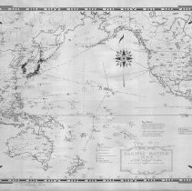
Pacific Battle Map designed and drawn by Ernest Dudley Chase of Winchester, Massachusetts, U.S.A. |
Collection |
Maps and Plans |
Object Name |
Map |
Date |
1942 |
Scope & Content |
Pacific Ocean and its islands, countries and ports. Distances are approximate for distances from countries to some of the islands. Legend & symbols for British, combined British and U.S., French and Japanese possessions and islands of the Netherland Indies. Time zone legend. Signed by Chase. |
Copyrights |
Permission to publish material from this collection is subject to approval by the Town of Winchester. |
Subjects |
Asia -- Maps Australia -- Maps North America -- Maps World War, 1939-1945 - Maps Pacific Ocean |
Search Terms |
World War II |
People |
Chase, Ernest Dudley |