Archive Record
Images
Metadata
Catalog Number |
1300.29 |
Title |
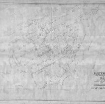
Waterfield (now Winchester & Woburn) 1638 with the relative positions and boundaries of the original land owners. |
Collection |
Maps and Plans |
Object Name |
Map |
Date |
1638, 1886 |
Scope & Content |
The area encompasses early Winchester when it was known as Waterfield. It shows lots with owners' names, roads, ponds and rivers in 1638. This map was then drawn with an overlay of the names of streets and roads as they were known in 1886. It was drawn to accompany an article written by George Cook in the Winchester Record of January 1886. The reproduced map was drawn by James Hinds, town engineer in June 1930. There are four copies of the map, all reproductions on paper. Copies 1-3 are printed in blue ink and are in fair condition; copy 4 is printed in brown ink and is in poor condition with the northern area missing. Copy 1 is encapsulated. |
Copyrights |
Permission to publish material from this collection is subject to approval by the Town of Winchester. |
Subjects |
Plans Plats Roads Streets |
Search Terms |
Waterfield |