Archive Record
Images
Metadata
Catalog Number |
1300.34 |
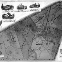
Title |
1854 map of Winchester |
Collection |
Maps and Plans |
Object Name |
Map |
Date |
1854 |
Scope & Content |
This is a graphic mock-up of the 1854 map of Winchester. The six divisions of the town are in the center and the nine insets are placed around them. It is in fair condition. |
Copyrights |
Permission to publish material from this collection is subject to approval by the Town of Winchester. |
Subjects |
Plans Plats |
Search Terms |
First Congregational Church Lyceum Building mahogany mills |
People |
Cutter, Stephen H. Judkins, Jerome B. Parker, Harrison Thompson, Stephen Walling, H.F. Woodbury, James A. |