Archive Record
Images
Metadata
Catalog Number |
1300.127 |
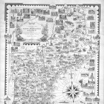
Title |
A Pictorial Map of the New England States U.S.A. Designed and drawn by Ernest Dudley Chase of Winchester, Massachusetts. |
Collection |
Maps and Plans |
Object Name |
Map |
Date |
1938 |
Scope & Content |
Each state has illustrations depicting key cities and buildings, industries, farming, recreations, rivers, lakes, mountains and monuments. Approximately forty-five insets depicting government buildings, historic homes, churches, colleges. Signed by Chase. |
Copyrights |
Permission to publish material from this collection is subject to approval by the Town of Winchester. |
Subjects |
New England -- Maps United States -- Maps |
People |
Chase, Ernest Dudley |