Archive Record
Images
Metadata
Catalog Number |
1300.01 |
Title |
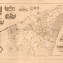
Map of the Town of Winchester, Middlesex County, Mass. 1854 |
Collection |
Maps and Plans |
Object Name |
Map |
Date |
1854 |
Scope & Content |
Early map of the town surveyed by order of the town by H. F. Walling, engineer, in 1854. Signature at the bottom "Presented by Stephen Thompson." The divisions of the town are indicated as well as topographical features. Land owner's names appear where they live. There are eight pictoral insets. This is not the original map, but a copy that has been reproduced and sold by the Winchester Historical Society. |
Copyrights |
Permission to publish material from this collection is subject to approval by the Town of Winchester. |
Subjects |
Plans Plats |
Search Terms |
First Congregational Church Lyceum Building mahogany mills |
People |
Cutter, Stephen H. Judkins, Jerome B. Parker, Harrison Thompson, Stephen Walling, H.F. Woodbury, James A. |