Archive Record
Images
Metadata
Catalog Number |
1300.37 |
Title |
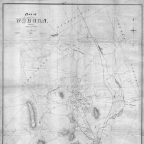
Map of Woburn, published with the Woburn Directory by John L. Parker, 1874. |
Collection |
Maps and Plans |
Object Name |
Map |
Date |
1874 |
Scope & Content |
This is a street map of Woburn in 1874 surveyed and drawn by H.M. Wightman. It encompasses Whispering Hill, Zion's Hill, Cummingsville, Mt. Pleasant, Woburn Center, and Horn Pond. No names of owners are listed. The map is in fair condition and is encapsulated. |
Copyrights |
Permission to publish material from this collection is subject to approval by the Town of Winchester. |
Subjects |
Streets |
Search Terms |
Woburn Winter Pond Wedge Pond |