Person Record
Metadata
Name |
Chase, Ernest Dudley |
Related Records
-
-

-
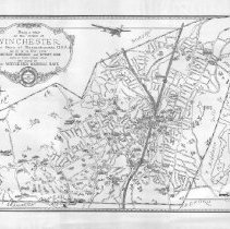
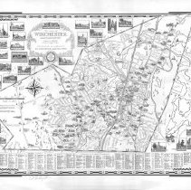
1300.103 - Being a Map of the Town of Winchester in the State of Massachusetts, USA as it is in the year Nineteen Hundred and Twenty Nine; drawn by Ernest Dudley Chase and issued by the Winchester National Bank.
Maps and Plans
Record Type: Archive
-
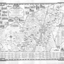
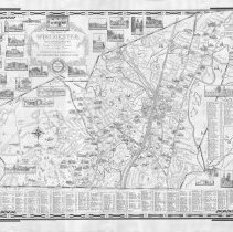
1300.104 - The Town of Winchester, Massachusetts Drawn in 1941 and Brought up to date in 1952 by Ernest Dudley Chase. Distributed with the compliments of The Winchester National Bank.
Maps and Plans
Record Type: Archive
-
1300.105 - The Town of Winchester, Massachusetts drawn in 1941 and brought up to date in 1957 by Ernest Dudley Chase. Distributed with the compliments of the Winchester National Bank.
Maps and Plans
Record Type: Archive
-
1300.106 - The Town of Winchester, Massachusetts drawn in 1941 and brought up to date in 1964 by Ernest Dudley Chase.
Maps and Plans
Record Type: Archive
-
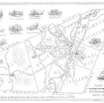
1300.107 - Map of Winchester, Mass. 1854. This map adapted by Ernest Dudley Chase form one by H.E. Walling, published in 1854.
Maps and Plans
Record Type: Archive
-
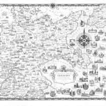
1300.108 - A Pictorial Map of Germany by Ernest Dudley Chase of Winchester in Massachusetts, U.S.A.
Maps and Plans
Record Type: Archive
-
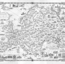
1300.109 - Europe, a pictorial map by Ernest Dudley Chase of Winchester, Massachusetts, U.S.A.
Maps and Plans
Record Type: Archive
-
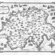
1300.110 - A Pictorial map of Switzerland by Ernest Dudley Chase of Winchester Massachusetts, U.S.A.
Maps and Plans
Record Type: Archive
-
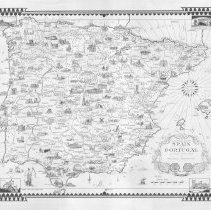
1300.111 - A Pictorial Map of Spain and Portugal by Ernest Dudley Chase of Winchester, Massachusetts
Maps and Plans
Record Type: Archive
-
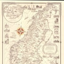
1300.112 - Norway Sweden Denmark by Ernest Dudley Chase of Winchester, Massachusetts
Maps and Plans
Record Type: Archive
-
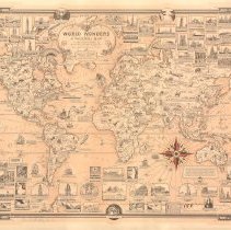
1300.113 - World Wonders; a pictorial map designed and drawn by Ernest Dudley Chase. Winchester, Massachusetts U.S.A.
Maps and Plans
Record Type: Archive
-
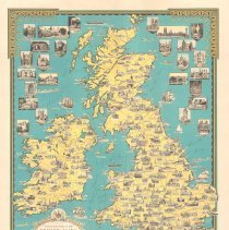
1300.114 - A Pictorial map of the British Isles by Ernest Dudley Chase
Maps and Plans
Record Type: Archive
-
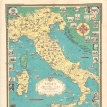
1300.115 - Italy with Vatican City as drawn and published by Ernest Dudley Chase of Winchester, Massachusetts USA
Maps and Plans
Record Type: Archive
-
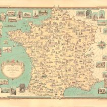
1300.116 - France as drawn by Ernest Dudley Chase of Winchester, Massachusetts USA
Maps and Plans
Record Type: Archive
-
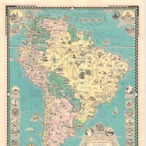
1300.117 - The Good Neighbor Pictorial Map of South America designed, drawn and published by Ernest Dudley Chase Winchester, Massachusetts
Maps and Plans
Record Type: Archive
-
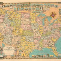
1300.118 - America the Wonderland, a pictorial map of the United States designed and drawn by Ernest Dudley Chase of Winchester Massachusetts
Maps and Plans
Record Type: Archive
-
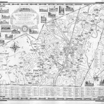
1300.119 - The Town of Winchester, Massachusetts drawn in 1941 by Ernest Dudley Chase. Distributed with the compliments of the Winchester National Bank.
Maps and Plans
Record Type: Archive
-
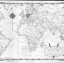
1300.120 - The Atlantic and Indian Ocean Battle Map designed, drawn and published by Ernest Dudley Chase Winchester, Massachusetts U.S.A. Certain Victory Must be Ours!
Maps and Plans
Record Type: Archive